
This article on hiking the Rice River Canyon was created in partnership with Saskatchewan’s Outback: The Town of Carrot River during a multi-day media trip. But as always, all thoughts, opinions and advice are genuinely and honestly my own.
I’ve wanted to hike the Rice River Canyon for more than half a decade. It’s a trail I’ve read about in Robin and Arlene Karpan’s book The Great Saskatchewan Bucket List and then again on Andy Goodson’s Sask Border blog.
The allure of its remoteness and wildness appealed to me. But it wasn’t until this year that I finally made it happen thanks to the town of Carrot River and their invitation to come visit the region.
For those who are interested in hiking into this remote area of Saskatchewan, here is everything you need to know to have a safe and successful trip.


Trail Logistics
| Trail Length: | 10.8km one way, ending at the river forks |
| Trail Difficulty: | Challenging – prior wilderness experience and backcountry hiking and camping experience is highly recommended |
| Trail Elevation: | 345-metre elevation hiking into the river forks, 75-metre elevation hiking back out to the bridge |
| Trail Type: | No actual trail – hiking along a riverbed |
| Facilities: | None – there is a parking lot at the bridge but there are no official campsites or bathrooms along the trail. The parking lot is not monitored so make sure to leave all valuables at home. |
| Cell Service: | There is no cell service along the trail (service may be intermittent but not reliable for the first 1-2 km.) It is highly recommended to leave a hiking plan with someone and carry in a GPS or In-Reach satellite communicator |
| Campsites: | No real campsites but primitive fire rings can be found along the river in different locations. A campfire ring and log benches are at the end of the hike at the river forks |
| Bear Caches/Lockers | None available. Food must be hung in the trees to keep out of reach of bears. |
| Trailhead Location: | Located 94km east of Carrot River on Highway 55. Google map linked here. |


About the Rice River Canyon
Rice River Canyon Ecological Reserve is located on the northwest side of the Pasquia Hills. The river begins in the hills in the north, forks into two tributaries and drains into the Carrot River in the south.
Steep and silty valley walls more than 120 metres high have been carved into the 20km long river valley over the last 12, 000 years. The Cumberland Delta can be seen in the north when hiking at higher points along the trail.
White and black spruce, balsam poplar and white birch form part of the plateau while 14 rare and 16 endangered plant species call this ecological area home. Animals frequently roam the region and it’s not uncommon to spot signs of them including bear scat and prints from wolves, cougars and moose.
Iron-rich groundwater and sedimentary rock stain the landscape blood-red in places. Rocks are stamped with signs of life from 240-400 million years ago; fossils are found all along the riverbed if you look closely enough. Garnet, the gemstone responsible for many of the purple sand beaches found in Saskatchewan, can also be found in the rocks.


Top 5 Most Important Hiking Tips for This Trail
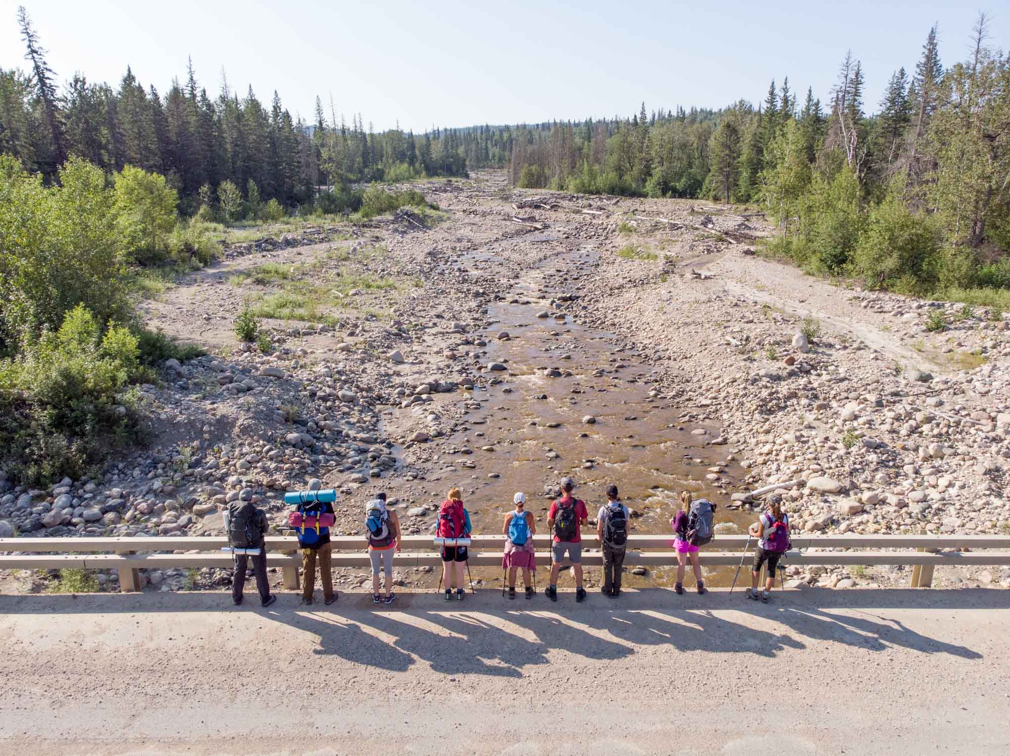
This is not your average hiking trail as there really is no trail to follow. Hikers will “choose their own adventure” up the Rice River canyon, encountering large boulders and dozens of 30-metre-long washed-out trees to climb up, over and around – all while zig-zagging across the flowing Rice River. It’s a chaotic but beautiful mess of nature to look out on and hike amongst.
Water levels range from ankle-deep to more than waist-deep depending on the time of year and point of crossing. There is no way to avoid traipsing through the water as steep walls and dense bush makes hiking through the forest essentially impassable. Late summer and early fall are ideal times to hike this route.

Five tips to make your hiking experience easier:
1. Bring Hiking Poles
The river bed is littered with a variety of sizes of rocks even in the shallowest sections. Hiking poles make trekking through the water much quicker, safer and easier.
Poles I recommend: I’m always a fan of Black Diamond Trekking Poles.
2. Wear ankle-high hiking boots that aren’t waterproof
It’s counterintuitive to wear non-waterproof boots on a hike you know you’ll get wet on. But the river crossings are higher than the top of your boot, so you’ll be unable to keep the water from pouring in. Gaiters may help but they’re also hot to wear on a midsummer’s day and are only protective up to the knee.
Choose mesh hiking boots that let water flow out when you’re walking on dry ground. (My leather boots held all the water in which made for a squishy hike). Also recommended are boots that cover your ankles. I braced my ankles against rocks while crossing the river. This offered much more protection than for those who were wearing hiking shoes or sneakers.
Hikers I recommend? I’m a big Keen fan and own several of their hikers. I recommend the Explore Vent Hiker for this trail.

3. Pack bug spray
Northern Saskatchewan is notorious for bugs whether it’s black flies, sand flies, horseflies or mosquitoes. Although the breeze kept most of the bugs at bay during our trip, a full can of bug spray is a smart choice.
Bug spray that works: I carry a lightweight 30ml bottle of Ben’s 30% Deet for most hikes but am also a big fan of Watkins lotion and spray. When at the campsite, I always light a mosquito coil or two – they work amazingly!
4. Don’t always hike next to the river
On the hike in, we stayed relatively close to the winding river but found it more tedious and time-consuming. A quicker route is weaving along the drier river bed closer to the treeline. There are fewer downed trees to hop over and it’s quicker to walk.
Also of note when hiking out, it was easier to see a natural path around trees and rocks because of the drop in elevation versus hiking in.
5. Pack rope
There are no bear caches or lockers on this hike but plenty signs of bears. Pack in at least 15 metres worth of rope to be able to safely hang your food in the trees.

Day Hiking the Rice River Canyon
Day hiking the 21.6-kilometre roundtrip route to the river forks is a challenge left for only the most well-prepared and adventurous hikers (re: it’s not advised for most people).
However, the riverbed is a fantastic location for exploration on a short day trip. Recommendations include bringing a picnic lunch and hiking a couple hundred metres or a kilometre or two up the river from the bridge. There are lots of fossils for kids to search out but the true beauty of the hike comes in the nearly vertical valley walls arcing up from the river.
There is no cell service. Be prepared and carry in food and snacks, a small first aid kit, warm layers, sunscreen, bug spray and extra water or a water filter.

Overnight Hiking the Rice River Canyon
The canyon is best experienced on a one or two night backcountry hiking trip into the river forks.
There are several campfire rings within the first couple kilometres of the trailhead as well as a campfire ring at about the 7-kilometre mark. (Stone campfire rings can be easily missed in the wide floodplain).
We hiked all the way into the river forks and camped at the primitive campsite on the west side of the river. Logs had been positioned as benches and we upgraded the firepit to a second ring of rocks. There are several flat areas and rock-free spots perfect to pitch tents.
We chose to hike the trail in one night but several other groups I’ve chatted with did it in two nights. It took us roughly 5-6 hours to cover the 10.8 kilometres with plenty of time for snack breaks and a lunch stop.
On day one we hiked as a group of nine (four were day hikers and they turned around at the 5-kilometre mark.) Our progress was slower in such a big group and we were covering about a kilometre per hour. However, on our return the next day, we made much quicker time not only because of the smaller group size at river crossings but also because the hike out decreases in elevation and our route was easier to see.

TIP: Instead of hiking all the way to the river forks with loaded packs, it’s easy to set up camp at the 5 or 7-kilometre point and hike the rest of the trail without the weight of gear. Make sure to either hang your food before you go or carry it with you in a day pack to keep it away from bears.
*If you hike in and stay overnight, please pack out everything you brought in with you – including your garbage and empty tin and aluminum cans. Please leave the area as you found it so others can enjoy it too.
Rice River Canyon is truly a unique wilderness hike for those seeking adventure. The scenery is unlike most destinations in the province and the trip is highly rewarding for those that choose to attempt it.

What to do in Carrot River
I’d highly recommend stopping in Carrot River on your way to the trailhead. Whether it’s to pick up home-cooked meals on the way, explore their ancient history or spend the night, here are a few spots you’ll want to add to your list:

STAY:
Shell’s Fitness and Soul Centre – located on an acreage 7km south of Carrot River, Shelley’s studio is a combination fitness centre, obstacle course, yoga studio and retreat centre. There are tiny cabins on-site for rent and access to an outdoor kitchen. Contact Shelley directly to arrange for an overnight stay.
Carrot River Inn – the Carrot River Inn offers a big-city hotel feel in a small town.
Pasquia Regional Park – the regional park is a great location to pitch a tent or pull a camper in for the night. There’s an on-site 9-hole golf course, a mini-golf course for kids and a swimming pool. There’s also an on-site restaurant and an interpretive centre with a life-size replica skeleton of 92-million-year-old Big Bert the crocodile.
READ MORE: The Best Campgrounds, Cabins & B&B’s to Stay at in Hudson Bay

EAT:
Prairie Angel Bakery & Patisserie – It’s not often you’ll find a patisserie in a small town and Betty’s doesn’t disappoint. Stop in for sweet pastries and treats or take a sandwich to-go. (It’s perfect to pack in a cinnamon bun and calzone from Betty’s for your hike on the Rice River.)
Cilantro Bar and Grill – the local fine dining establishment offers meals made from local producers as well as pizza. It’s a great spot to grab a bite if you’re staying in the attached Inn.

SHOP:
Lillies and Lace Boutique – recently opened, owner Amanda sells cute clothing for women and men, lingerie items and giftware. It’s also a floral shop.
Carrot River Pharmacy – not just a pharmacy, you can also pick up locally made goods like Summer Spray (made in Moose Jaw) and tee’s made by Tisdale’s Little Town Apparel plus more.

Country Chic Saskatchewan – sells quirky and clever handmade signs as well as a variety of items made by local artists and creators. They also offer sign-making workshops around the province.

EXPERIENCE:
The Shale Big Bert Site – while in town, drive out to check out The Shale. In the 1990s, a 92-million-year-old crocodile named Big Bert was found at the site. There is a parking area and a mowed hiking trail down to the Carrot River. Be cautious descending the river banks as it can be muddy and slippery. Kids and adults will have a great time exploring the riverbanks looking for fossils and playing amongst the shale rock.
Trout Pond – an annually-stocked trout pond is only a 5-minute drive east of town. There is a large dock to fish from and it’s a great family-friendly activity.

Archery Range – at the east end of town is a well-kept outdoor archery range. A Saskatchewan Wildlife Federation membership is required but you can purchase one from the town office. A selection of free-to-use beginner bows and arrows can also be borrowed for use on the NASP lane at the range.
Save these hiking details for later and Pin it to Pinterest!


Such a great post and so informative. We might do this with our kids but maybe in two days.
For someone like myself who’s never been up there these photos make me anxious I wanna get up there so bad. We have been Twitter buddies about 4 years I think now is that correct Ashlyn ? Anyways every year I tell you im coming up and I never really plan it out but im coming im not sure when but within the next year. Anywsys those photos are absolutely gorgeous I love nature I love the mountains and all that ill make sure to go and buy a nice camera to capture each moment so I can show everyone when I come home. Thanks for all you do capturing all these gorgeous beautiful pictures for all to see. You definitely bring the tourist up there and because of you Ash most business im sure do good because of the tourism you bring up there. You do more for people by taking photos then you know everyone up there should be grateful for you pitching in and doing your part….. your awesome. Ashlyn George we love you………I love ya kiddo Nick/NYC
Very informative guide! I never knew about this trail and I’m amazed by how different and challenging it looks from the rest of hiking trails in the province. Thanks for sharing your insights and photos.